Sept 7th, 2020: The Lions
- Elaine
- Sep 7, 2020
- 4 min read
Updated: Aug 31, 2022
Type of hike: Out and back
Time (approx): 6 hours 20 mins
Distance: Around 18.5km

Hello, and welcome to the Lions!
The Hike
I realized I have not explored many trails in the Greater Vancouver area so when a friend recommended the Lions to me, saying it was tough and definitely a good challenge for the legs, I decided to give it a try.
The majority of the trail was in the forest. The first 30 minutes or so was uphill, but the incline was not steep enough for it to be overly taxing. It was quite well maintained, and the path was wide. After that, the path got a bit more narrow, but still well-kept and visible. There were also some wooden signs pointing in the direction of the Lions (Binkert) Trail.
The first 1/3 of the hike was not very exciting, just mainly meandering through the trees and various fauna. For such a popular trail, I was surprised by the amount of cobwebs that got caught in my face and arms, but thank goodness it was nowhere as bad as Mount Price.
I reached the bridge over the water stream fairly quickly, and this was the point many people mentioned in reviews on AllTrails to relish because it was going to be all uphill from there on.
The first part of the uphill battle was not that bad. It continued on in the forest, with lots of loose soil, rocks and tree roots jutting up from the ground. Some of the steps were almost at my hip level. It sort of felt like Grouse Grind on steroids. There were definitely sections which looked impossible but the trail was very clearly marked that said, "yes, this looks suspicious but you are on the right path".

It got progressively worse. At one point it was a bunch of boulders to clamber over; sometimes there were fallen tree trunks blocking the path and I had to straddle them to cross.
After spending about 45 more minutes in the forest, I finally emerged into the uncovered part of the trail. It was a relief to see the clear blue skies again - I was getting a bit bored by the lack of visual stimulation.
There was about two minutes or so of relatively flat ground here, which gave my legs a bit of a break before more scrambling. Here is a picture of what the scramble in the open air looks like (the camera is pointing downwards):

Some hikers stopped here because the views were gorgeous enough already. However, I would have felt like I didn't complete the entire trail if I just stopped here. Plus, the view was only about 180 degrees at this point. I wanted the full 360 degrees experience.
This last scramble up to the top was the truly challenging and it required getting on all fours. Also, even though there were ribbons to mark a path, I found following it tough, especially since some of the rocks were unstable and there were other people trying to get down. It took me about an hour just to get through this part. It seemed like it was never ending.
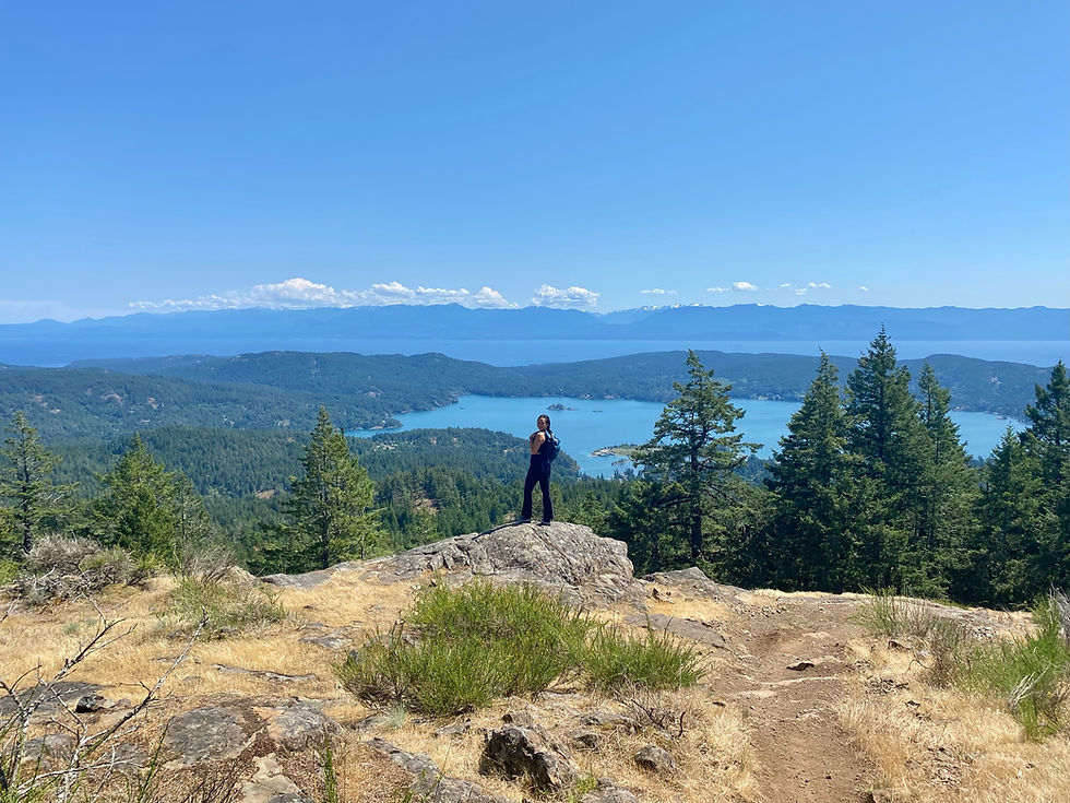
I actually went beyond what the AllTrails map indicated was the end. In fact, I got all the way to the top of the West Lion, which gave me the panoramic views I wanted. The only thing blocking it was the East Lion:

Here is what the full view looks like:
I could be wrong but I believe this is Unnecessary Mountain in the distance:

I was also able to see West Vancouver from here (super tiny though):

I spent about half an hour up there, eating lunch and drinking in the view. The sky was almost cloudless, the warmth of the sun felt really nice on the skin, and there was a light breeze as well. It was very calm and peaceful.
The climb back down was very hard on my knees. Surprisingly, the scramble part was not too bad, but I guess that was because I had so much practice at Garibaldi over the weekend. The difficult part was the forest section with the loose soil, rocks and tree roots. Maybe my legs were getting tired from all the hikes I put them through for the past four days - I found myself tripping and almost twisting my ankle a few times.
What I brought:
Bug spray. Luckily, the mosquitoes and bugs on this trail were not as bad in comparison to most of the other trails.
Bear spray. All hikers should have this with them at all times.
Bear bell. I thought there was going to be more people as it is a pretty popular trail, but turns out it was relatively quiet.
Hydration pack. Once again, 2.5L was not enough water. I really need to get a bigger one.
Decent amount of snacks.
Lip balm and eye drops.
Wet wipes. Very dusty.
Portable charger.
TP. Only one outhouse at the start of the trail.
Overall thought:
I am glad I took the time to try out some local Vancouver hikes, but I definitely prefer Garibaldi or Whistler. Don't get me wrong, the view at the top was gorgeous, but all I saw were water and trees. Lots of them. It makes sense because there are so many forests surrounding Vancouver, as well as on islands like Bowen Island. However, the views further up north offered more variety - in addition to trees and water, there are also glaciers, snow caps, meadows and wildflowers. For the amount of effort needed to complete this trail, I was expecting a bit more. It was a nice challenge but I would rather spend my time and effort on other trails up north. But if you are someone who is looking for a hike nearby that offers great views and a decent challenge, this would be perfect.


Comments