June 28th, 2023: Mount Manuel Quimper
- Elaine
- Jun 28, 2023
- 4 min read
Updated: Oct 8, 2023
Type of hike: Loop | Time (approx): 3 hours and 5 minutes
Distance: Around 10.4km | Elevation Gain: 478m
What to expect:
1) A bit more challenging than AllTrails states!
2) Bird's eye view of Sooke Inlet and East Sooke Regional Park
Some important info:
1) No outhouses along the trail but there is one in the parking lot
2) Decently shaded until halfway and then it becomes quite exposed
3) Second half is steeper with more loose dirt and rocks
What to bring:
1) Poles! It will definitely help
2) 2L of water, it's really hot up there
The Hike
The trail starts at the parking lot of Harbourview Road, where there is a good amount of parking available, as well as a washroom facility. We got there around 1pm in the afternoon on a weekday and the lot was pretty much empty. It's recommended you tackle this trail counter-clockwise but we did it clockwise, but honestly I feel like the difficulty would have been the same either way.
The first half hour on Sooke Mountain Trail was a slow and relatively flat incline, which was great as a warm up. The trail was wide and had only bits of loose dirt and gravel. The weather was hot and sunny that day, but luckily this section provided quite a bit of shade so we didn't burn that much. I noticed there were some berries along the way as well.

As soon as we made a right turn onto Quimper Connector, the trail became a bit more challenging and wacky. Lots of protruding tree roots, loose dirt and boulders dotted the terrain, and the trail became narrower and more exposed, though there were still chunks that were shaded (thankfully). The incline became more pronounced, and my feet were finding it more and more difficult to get a good grip in all of the loose dirt. I didn't bring my poles with me this time, and I wish I did - would have helped a ton.
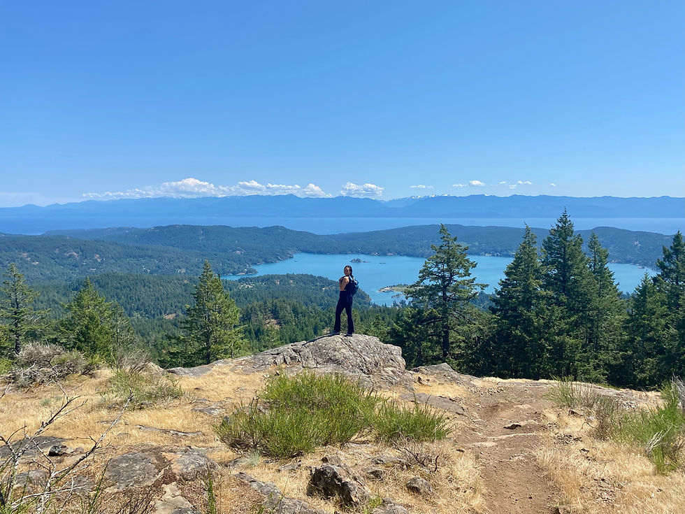
About another fifteen minutes in, we emerged out of the vegetation and trees, and the rest of the trail was pretty much in direct sunlight. The trail was also getting steeper by the minute so we were definitely working up a sweat. Around this time, I had to stop to catch my breath, and turned around to see how far we've come on the trail. Instead, much to my surprise, I was greeted by a bird's eye view of Sooke Inlet, the East Sooke Regional Park, and the ocean beyond. The water was a beautiful blue and glittering brilliantly in the sun. In the distance, we could make out Olympic National Park in Washington.

That's how crystal clear everything was! The scenery made me pause longer than expected as I tried to soak it all up. Then I remembered we weren't even at the top of the summit, and the view was already this splendid.
The next fifteen minutes or so was a grind. We both were wondering how could a trail like this be rated moderate. This section reminded us of the Goat Ridge trail which we did a few days prior to this one. We definitely didn't feel as gassed as we did on Goat Ridge, but the effort was almost comparable! Also, as this was pretty exposed the whole way to the top, I felt parched constantly.
When we finally made it to the top, we found an abandoned fire watch tower. Back in the 1970s it was used to watch for summer fires as this was the tallest point in the region. It was super hot inside the tower so we just took a peek and had to leave (there's a notebook on the counter where hikers wrote the date they did the trail and a little note). The views up here was just as spectacular as the viewpoint earlier, just a big higher so we could see more of everything. The sky was completely clear and free of clouds, so the whole scenery was pretty much picturesque.
The way down was not the greatest, especially without poles. That is the issue with sharing trails with mountain bikers - those trails tend to be steeper with lots of loose dirt, which is great for the bikers but not so much for the hikers. There were less protruding tree roots and rocks on the way down, so we had to spend extra time picking our way gingerly so we wouldn't slip.
My Thoughts
This trail was rated moderate on AllTrails, but I honestly feel like it should be rated hard! The first few kms were easier so I understand why they might have rated it this way, but the last few kms were definitely challenging! I really recommend bringing poles. As this mountain is also home to horseriders and mountain bikers, there are many different forks and turns to take. I suggest keeping a close eye on your chosen trail’s map with a close eye, otherwise you might end up on a mountain biker’s trail that is even dustier and steeper than the one we were on!
The view were definitely worth it, and honestly, I did love the trail itself. I would love to come back one day to explore other trails in this Sea to Sea Regional Park. I found it was a good mix of shade and exposed terrain.


Adding it to my list for summer 2024!
Adding this to my bucket list!!
Wow it looks beautiful!