St. Mark's Summit Hike Review: Everything You Need to Know
- Elaine
- Jul 4, 2020
- 3 min read
Updated: Sep 30, 2024
St. Mark's Summit offers incredible views of Howe Sounds and the surrounding islands. This hike takes you through the forest before reaching the summit, where you'll see panoramic vistas that make the effort worth it. Best to visit on a clear sunny day because otherwise you won't see anything at the top!
Type of hike: Out and back
Length and time: AllTrails notes this trail is 11km and generally takes 3 hours and 45 minutes to complete.
Difficulty: I would say moderately challenging, obviously depends on what fitness level you start out with. It's not a super technical hike (soft soil, rocks and roots) and just requires a bit of endurance especially with the steeper parts closer to the summit.
Elevation Gain: 570m
Dog friendly? Yes
Best time to visit: July to September (but it is open until October)
Distance from Vancouver: 30 minutes
Parking? Yes, in a lot
What to expect for this hike:
Terrain can be a little messy, especially after rain, but it's well maintained otherwise and markers are easy to follow
Can get super buggy though, and we experienced lots of flies and mosquitoes
It's a pretty shaded hike due to the forest section, so no need to worry too much about getting sunburnt. There are a few open sections though, but not much. This also means the temperature can get a little chilly at times.
As the hike starts from the bottom of Cypress Mountain so plenty of parking all around.
I don't remember seeing an outhouse for this trail at all.
Always practice the Leave No Trace principles.
Suggestions on what to bring:
Best waterproof shoes you've got because the trail can get super muddy!
Bug spray
Hydration pack (I also don't remember seeing water sources on this trail)

July 4th, 2020
Time: 5 hours (we were not very fit at the time)
Distance: 12 km
I personally would say this was a difficult hike due to the condition of the trail itself at the time we went. It starts on Cypress Mountain and for the first kilometer or so, the path is relatively easy. There is a bit of elevation but nothing too steep.
After entering the forest, the path goes up and down quite a bit, but again, nothing too hard on the knees or joints. We were able to keep up a conversation so that tells you a bit about the intensity.
However, by the time we reached two quarters of the way through, that was when the trail really got messy. The trail itself pretty much disappeared under all the mud. There were tons of exposed tree roots, slippery mud and loose rocks. It had also previously rained so some of the mud puddles were meters wide and ankle deep. We were able to get around it using tree branches but at some point there was no way across except straight into the mud. Needless to say, our shoes were destroyed.
The steep-ish incline and wet mud made lots of little mudslides that were quite dangerous (and entertaining to try to maneuver around). Since the trail is out and back, the traffic flows both ways and (mostly) everyone was trying to do their best to social distance but these mudslides made it hard.


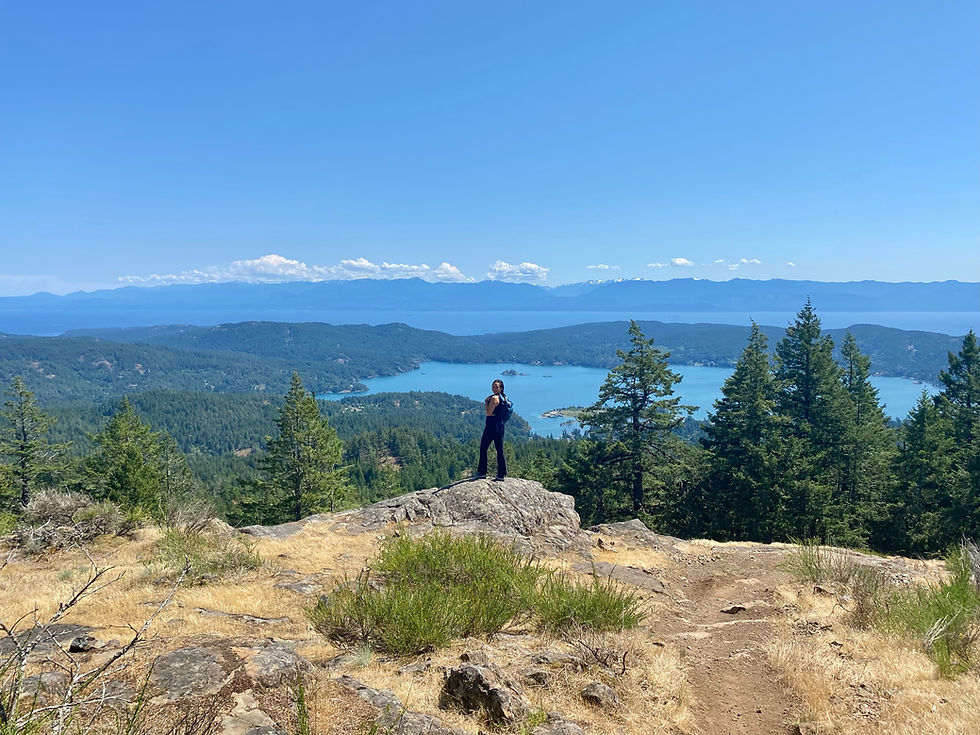
There are a few lookouts during the trail but I cannot quite remember them all. There is a viewpoint about one third of the way in that allows you to see the Lions off in the distance. At the top of the summit, you can see Unnecessary Mountain and Howe Sound.
Disclaimer: I just moved to Vancouver about a year ago at the time of writing this post, and was still unfamiliar with its geography. Apologies if what I am describing does not 100% match the pictures.
The pictures above are from the lookout at the very top. You would definitely be able to see much further off into the distance on a clear day but when we went, it was a bit cloudy.


I agree this hike is so fun! Although so close to the city you can get detached in the beauty and feel so one with nature. This hike did however make my stomach feel uneasy due to the cliff.