Sept 11th, 2022: Golden Ears Summit
- Elaine
- Sep 11, 2022
- 6 min read
Updated: Jul 11, 2023
Type of hike: Out and back | Time (approx): 13 hours 45 minutes
Distance: Around 22km | Elevation Gain: 1695m
What to expect:
1) Prepare to experience a few different landscapes - forest, rocks and boulders, scrambles
2) It's a long hike and can be very taxing
3) Last 1.5km to the very top is a scramble up the peak
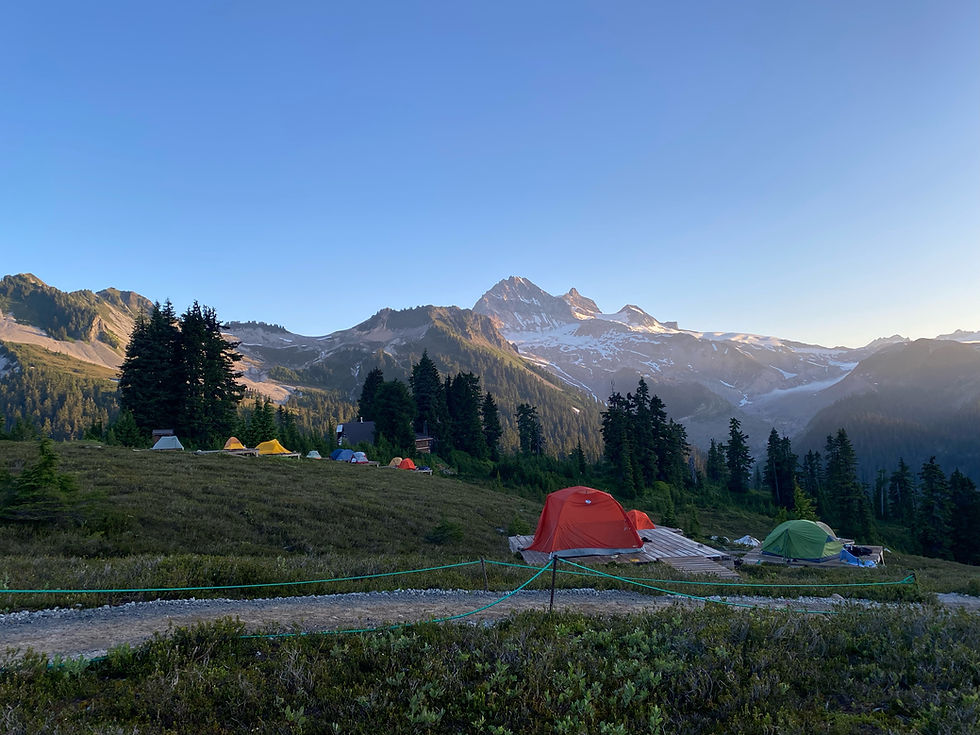
4) There are two campgrounds called Alder Flats and Panorama Ridge
Some important info:
1) I'm unable to recall if there were any outhouses at the campgrounds, though I imagine there should be
2) Shaded until you break out of the forest, and the scramble is exposed.
3) There are one or two places to refill your water bottle, one of them being close to Panorama Ridge campground
4) Having the downloaded map might be useful for the scramble as it is not very well marked
What to bring:
1) Poles will be helpful here
2) Lots of food and snacks as this trail really truly zaps all your energy
3) 3L - 4L of water, purifier tablets for refilling water, and electrolytes tablets just in case
4) First aid kit in case of injuries
5) Portable charger
6) Bug spray
7) Bear spray
The Hike
I don't think I have ever underestimated a hike this severely before. Maybe I didn't do enough research or read enough reviews, but I was under the impression this trail was relatively straightforward, and was going to be around 10 hours with a bit of a scramble at the end. I've been wanting to do for a while, and summer was quickly coming to a close. The days were already getting shorter, so I thought if I started early enough, I'd be able to make it down by dusk.
It was single-handedly one of the hardest hikes I've ever done.
The terrible air quality probably lent a hand to that. There were a couple of wildfire in EC Mannings and Idado and the smoke blew up north, covering most of Vancouver under a blanket of smog for a couple of weeks. I would've waited for the smoke to clear but there were about 11 hours of daylight already at this point, and I didn't want to wait another year. Back in 2020 I completed a few hikes in the smoke so I thought it wasn't going to be a huge problem.

The first leg of the trail up to just before Gold Creek lookout was relatively straightforward and easy to find. Then right before the lookout, the incline became a little bit more steep, and there were more rocks and boulders. There were orange markers here and there, but not enough to actually show the trail. I had to navigate using the AllTrails map.
The trail up to Alder Flats campground was nothing too difficult in comparison to what came after it. The landscape around the campground opens up enough for one to see what lies ahead (pictured below - I made a new friend on this hike named Sara who made this illustration to showcase the scramble at the end).

(No tent platforms for this campground by the way).
After Alder Flats, the trail became even more steep, and now consisted of only large rocks and loose boulders. It was tiring trying to pick my way through it, and I almost lost my balance a couple of times. It lasted for about 45 minutes. All of a sudden, I began to see all of these exposed tree trunks/roots and high steps everywhere, and it reminded me so much of Wedgemount Lake, but worse (I didn't even know that was possible). Most hikers at this point were just all on fours, and we were all just crawling our way forward.
After about an hour or so of this, the trees fell away and the landscape opened up completely. While it was nice to be out of the forest and finally be able to see the sky, the heat from the sun combined with the smoke made me consume more water than necessary. My eyes and throat were constantly dry. About thirty minutes later of being under direct sunlight, I was down to my last few drops of water - and I haven't even made it to the summit yet.
Luckily I reached Panorama Ridge shelter before I fully ran out, and was able to refill my water pack at a nearby stream. I looked up at the mountain looming up in front of me, and knew this last 1.5km was going to be awful. This was partly due to the fact that both my quads have been cramping pretty badly for the past hour already, and I had run out of food (as I mentioned...I underestimated this trail). It was definitely due to an electrolytes imbalance from all the water I was consuming, but I lacked the foresight to bring any electrolyte tablets with me. I couldn't take more than a couple of steps before having to sit down to release the tension in the leg muscles. It was going to struggle trying to get back to the trailhead, but I was determined to not give up, especially when I was so close to the top already.
There is basically no trail at this point. There are a couple of really faded trail markers (orange ones that have turned white in direct sunlight over time), but they were so far and few in between they were useless. There are a couple of cairns here and there, but again, not enough to actually mark a trail for people to find. Therefore, it was no surprise I went up the wrong side of the mountain, and actually had to rock climb to get to the top. Everything was basically vertical at this point, and any wrong step was going to be a very dangerous fall. I stepped on a very large boulder and it gave way, falling about three meters down. If there was anyone following me, they would have been hurt. My legs were burning badly and shaking at this point, but I couldn't give up or go back down now. So I continued, taking one step every minute, telling myself it would be worth it.
What should have been a 30-40minute trek took me 2 hours in the end. By the time I reached the summit, my legs were completely done for, and I was too tired to even feel my rumbling stomach. I crawled to the nearest rock and sat down, trying to catch my breath and not think about what the way back down would be like.
The views were nice enough, and the smoke made it seem almost surreal and mysterious somehow. Would I do this again though? Absolutely, but not a chance in this condition.

I met two lovely people at the summit named Sara and Jen. Jen was equally beat, and like me, had wanted to give up at some point during the last rock scramble stretch. They were super avid hikers, and we spent a couple of minutes chatting about some lesser known trails.
It was already 3pm and I had to leave soon, otherwise, I risked hiking in the dark (spoiler alert: I did end up hiking in the dark). My legs, which had stopped cramping the entire time I was sitting, immediately fired up again not five minutes into the descent. I pushed on, knowing there was nothing else I could do about it.
Once again, I lost my path down the scramble, and ended up going too far off to the right. Lucky for me, the two new hiker friends I met at the summit had decided to head down not too long after me, and I spotted them from the far off distance. I used them as a guide to at least get back to the Panorama Ridge shelter and off this insane mountain scramble. I met up with them at the shelter, and they offered to let me join them on the trek down. I gladly accepted because I was terrified of my legs giving out completely on me, and I didn't want to be stranded alone. They were also nice enough to give me energy gels and electrolyte tablets, which helped ease up my leg cramps quite a bit.
They were super nice people, and I enjoyed chatting with them on the way down. It made the journey faster and more fun. The way back down was fast, and I almost couldn't believe this was the same trail I went up just a couple of hours ago. Inevitably, the sky started turning dark, and before we knew it, the trees had blocked out the last of the daylight and we were walking in the dark. Again, lucky for me, Sara and Jen both had headlamps, and combined with my phone's flashlight, we were able to finally make it back to the trailhead by 9:15pm.


Comments