Mount Brunswick Hike Review: Everything You Need to Know
- Elaine
- Jun 27, 2024
- 5 min read
Updated: Sep 30, 2024
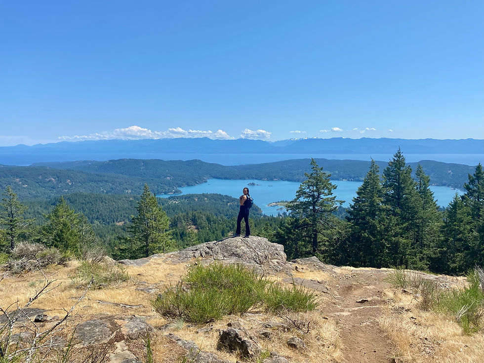
Mount Brunswick is the tallest peak in the North Shore Mountains and a serious challenge for avid hikers. This steep and strenuous trail rewards you with breathtaking 360-degree panoramic views of Howe Sound, the Lions, distant peaks, and the sparkling ocean once you reach the summit. If you're craving an intense and rewarding hike, this is for you!
Type of hike: Out and back
Length and time: 13.4km on AllTrails but people report closer to 15km in the reviews. Ours was longer because we included the distance from the free parking at the elementary school.
Difficulty: Extremely challenging. I would recommend fully researching this hike before you attempt it, otherwise you might be poorly prepared.
Elevation Gain: 1555m
Distance from Vancouver: 30 minutes
Dog friendly? Yes
Parking: Yes. Sunset parking lot, which is right at the trailhead, is pay by hour or pay by day. Last I checked, it was $3 for an hour or $24 for the whole day. It is almost impossible to find street parking because after Covid, everywhere has a no parking sign. You can try to find free parking at the overflow lot of the nearby Lions Bay Elementary School, but it'll add distance to the hike. Or you could get lucky with a couple of free spots right in front of the school, but you're only allowed to park there on weekends.
What to expect for this hike:
The terrain is harsh and demanding. I'm talking relentless incline, steep elevation gain in the second half, loose scree and rock scrambling, rugged conditions. It's a test of endurance. The first half is in the forest and shaded, but once you break out of it, you're in the open for the rest of the way. The final push to the summit felt like the longest hour of my life. Coming down felt worse than going up.
It's definitely got the best view out of all the North Shore mountain hikes I've done, probably because this is the tallest mountain there.
Due to the elevation, the temperature/weather can change drastically. When we first attempted, on June 16th, it was only drizzling in the parking lot, but full on snowing at the top.
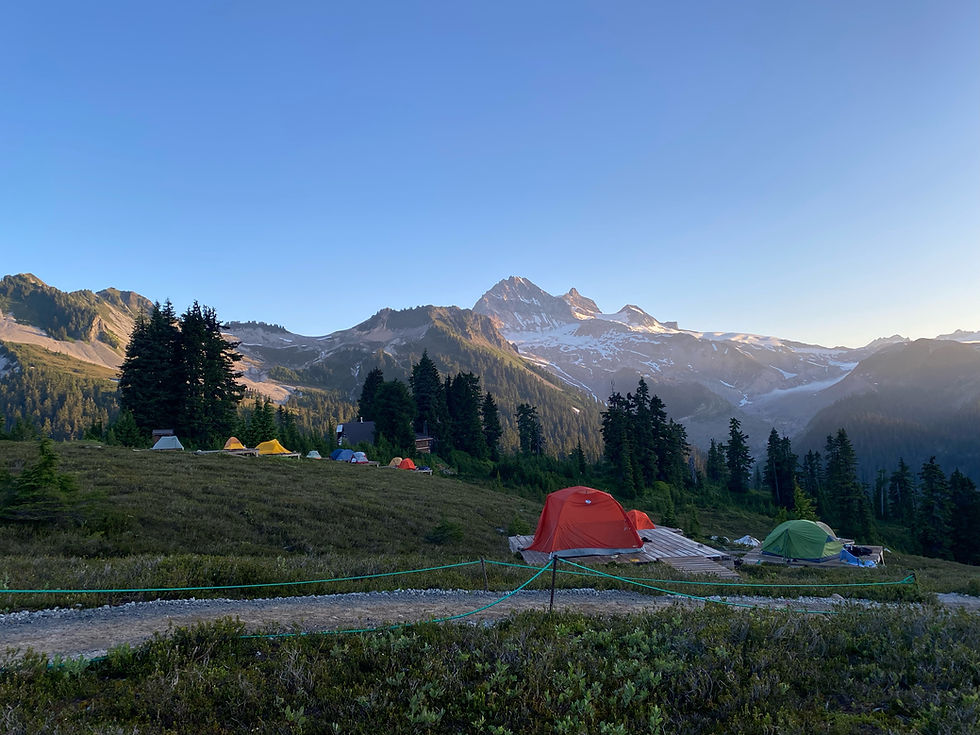
Only outhouse we saw was at the trailhead.
Always practice the Leave No Trace principles.
Suggestions on what to bring:
Bring as much water as you can. I brought 3L and I finished it all. There is no water sources on this trail so be extra prepared for that.
I have never been so grateful for my hiking poles. Ever. Bring them, and if you don't have any, buy them or find a way to borrow them. Your knees will thank you.

August 4th, 2024
Time: 7 hour 13 minutes
Distance: 17.58km
This hike is notorious for its tough terrain, but many people do it for the incredible panoramic views of Howe Sound, the Lions, Mount Harvey, and nearby peaks. Except for a brief 15-minute flat stretch, the trail is a relentless incline that will seriously burn your quads and calves.
Luckily (or unluckily, depending on whether you prefer sun or shade), most of the hike is in the trees. Personally, I find this kind of trail really boring — just endless brown slopes and the same trees for hours. The real views don’t kick in until about 3 hours in, during the final ascent.
This trail also connects to Tunnel Bluffs and the Lions. It starts at the Sunset Trailhead, where parking costs around $3 per hour or $24 per day (as of mid-2024). Free parking in the area has become nearly impossible post-pandemic, with "No Parking" signs and hefty towing fees everywhere. If you’re willing to park farther out, it’s cheaper but adds to your hike. You might get lucky with a few free spots at Lions Bay Elementary School, but they’re only available on weekends and very limited. Parking there adds about 20 extra minutes to the hike, which is what we did. We also couldn’t find the overflow lot for the school though.
The trail starts off wide and flat (not too hard on your feet) with a steady incline. There are a few switchbacks as it narrows, but it's still wide enough for two people to walk side by side. There isn’t much to see during this part.
Soon, we came across a cool signpost pointing to The Lions, Tunnel Bluffs, and Brunswick Mountain. Since we were heading to Mount Brunswick, we took a left at the fork. From here, the path narrows to single file, and for about 15 minutes, it levels out—definitely a welcome break after all that elevation gain. Be sure to make the most of this rest. The trail does get a bit gravelly with more rocks, but that’s about the only change in terrain.
We then crossed a slightly creaky wooden bridge, which is totally safe. Shortly after, we reached another sign directing us to either Brunswick or Tunnel Bluffs. Unsurprisingly, most hikers take a left toward Tunnel Bluffs since it’s the easier route. The path narrows even further here, with some overgrown brush. You might have to do a bit of bushwhacking, but overall, the trail is still easy to follow. The path slowly gets rockier too, so having your poles out at this point would be helpful (if you didn’t already).
We actually attempted this trail back on June 16th this year, and it was drizzling at the time. When we reached 2/3 of the way, not only did we see compact snow on the ground, but it also started snowing. Hence, we never finished the trail that day, and why we came back for it today.
There is a viewpoint at the 2/3 mark, but we didn't stop to check it out. We were already so tired and wanted to just finish the trail. That final stretch really tested our determination. It was so steep, and so rocky, you had to have four point of contact with the ground for safety. Not only was the terrain uneven, but there was so much loose gravel you run the risk of slipping off the edge. The average gradient here was 43%, and it just gets steeper and steeper and steeper...if that was even possible.

There was a "no fall zone” up ahead (this zone was promised to be so short and quick that most people won’t even notice it much, but I guess that really depends on how afraid of heights you are). After the ”no fall zone” is a sub summit where most people stop, but there is an even further true summit. It's a bit hard to explain so there might be Youtube videos that could visually explain better. It's called the sub summit because in order to get to the true summit, you will have to walk along a ridge. And that means you're walking on a narrow path with the slope of either side of you. We were happy to just stay at the false summit and have a place to sit. The views were gorgeous enough.

Saw a cute mouse on the way back down as well!


Comments