Sept 14th, 2020: Brandywine Mountain
- Elaine
- Sep 14, 2020
- 6 min read
Updated: Jul 11, 2023
Type of hike: Out and back | Time (approx): 5 hours 45 mins
Distance: Around 28.4km | Elevation Gain: 1464m
What to expect:
1) First 6km is in the forest with lots of switchbacks
2) The middle part is through a meadow so there were little waterfalls and streams to see, with patches of greenery
3) Trying to summit the mountain is a proper challenge - relentless, steep and not well marked at all
Some important info:
1) Getting to the trailhead is more difficult due to road conditions - a 4x4 is needed
2) This trail is usually a bit more populated but when I went there was not a single soul
3) Google/Apple Maps is not 100% accurate, make sure to read up on the "Getting There" section on AllTrails
What to bring:
1) Poles! It will definitely help on the way down
2) Bug spray and bear spray
3) At least 3L of water and high energy snacks
4) First aid kit in case of injuries
5) Portable charger as this is a long hike
The Hike
This trail was HARD. To be honest, half of it was not even hiking. It was part making-your-own-path and part trying-not-to-slide-off-the-mountain. I thought all the scrambles I have been doing over the past month would prepare me for this but unfortunately I don't think anything could have prepared me.
First of all, getting to the trailhead was an experience in itself. Neither Google Maps nor Apple Maps can correctly map to it, but luckily AllTrails has a "getting there" section. A 4x4 SUV is definitely needed due to the poor road condition and steep incline. You have to turn onto Callaghan Valley Road from Sea to Sky highway, and then take a left onto Brandywine FSR. From there, you drive until you reach a fork in the road - the right goes to upper parking lot and the left to lower parking lot. I did not find anything that resembled a parking lot, but there was a giant open space that looked like it could be meant for cars, so I just parked there and hoped for the best. Not surprisingly, due to the smoke in the air, I was the only one there, as well as for the entire hike. In fact, I did not see any humans until I drove back out to Callaghan Valley Road.
I parked right where AllTrails stated the trailhead was at, but for the first kilometer or so, I was walking on a road that looked like it was meant for cars. Then I found out, on the map, there was a parking logo right next to the spot where I saw a wooden stick with the words 'Brandywine Meadows'. I guess if you want to save yourself some walking, that would be the place to park instead (although this did not look like a parking lot either). This whole parking situation was just sketchy.
The first 6km was through a forest with lots of steep switchbacks. The trail was marked but sometimes spaced so far apart it was hard to find. The path itself was somewhat maintained, but there were plenty of sections where tree roots and loose soil were rampant, had mud deep enough to reach the top of my boots (yes, I got stuck in two of them), and even path forged by the trunks of fallen trees. Quite an adventure.
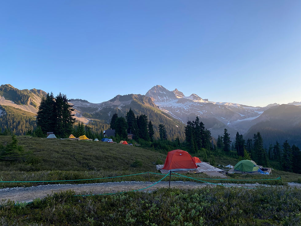
Around 7km in the trail opened up into the meadows. It was a relief to see open skies finally but unfortunately this weekend all I saw was smoke. It turned everything grey, including most of the sky.


However, I have to admit the meadows was beautiful nonetheless. The combination of grass, little water creeks, and patches of trees and rocks dotted here and there made everything picturesque.


In the distance, I saw what was yet to come - the scramble up this looming beast of a mountain.

People were not kidding when they said there was no trail up the mountain. There wasn't. A few small parts here and there indicated foot traffic but other than that, I found myself just scrambling up the mountain using whatever method necessary. Very quickly I came to realize the sections that were not covered by grass or rocks were the worst, because of how steep it was. My hiking boots simply could not grip the loose gravel and I felt like a 2x2 going on a 4x4 route. The grass was no better - since it was quite overgrown, it covered the potholes and the little streams of water from the creeks nearby. I lost count how many times I slipped and fell in those. The best option was to follow the giant pieces of rocks and gingerly step on them, making sure each was stable before I continued. Needless to say, this took an enormous amount of effort, brainpower and time. Most of the rocks were unstable. Thank God I caught myself because I could not imagine the pain or concussion I would sustain if I fell on one of these jagged objects.
When I was a child, I wondered what it would be like to literally climb up a mountain. Now I know. AllTrails map was useless. It told me which mountain is Brandywine, but I had to find my own way up. I worried every step of the way up how on earth I was going to get back down.
I never reached Brandywine mountain, which was the mountain NEXT to the mountain I climbed. Climbing up Brandywine mountain itself looked like it would require real rock climbing gear (and there is also a small waterfall to block your path). By the time I reached the summit of the first mountain, I was already tired and out of breath. The worry of having to go back down the mountain never escaped me for a second; hence why I saw Brandywine Glacier and told myself this was it. I needed to conserve energy for the way back. The glacier was this gigantic surreal-looking sheet of ice that covered much of the summit. It explained why suddenly the air got so cold.


I stopped for a break to regain some energy, and this is Brandywine Mountain from my vantage point (the smoke was quite thick at this elevation so everything looked very grey):

The climb back down was ten times worse, as expected. I felt my whole body shift into survival mode for the next two hours as I picked my way slowly down. I have never put so much care or thought into each of my steps in my entire life as I did here. Inevitably, I did slip several times, landing squarely on my tailbone. Twice I just started sliding until I managed to blindly grab at something to stop.
I did not follow the same path I took on the way up, partly because I was not able to remember it correctly, and partly because the ground (if you could even call it that) offered no traction for my shoes to grip properly. The only thing I remembered feeling very clearly was "I need to get down this mountain as fast as possible no matter what or how". It was a bleak attitude to an otherwise enjoyable activity.
Surprisingly, the way back to the trailhead went way faster than I anticipated. The switchbacks were hard on both my knees, especially after all that slipping and sliding. By now, the smoke has definitely made an impact on me because I could feel the burn at the back of my throat. I have never been so glad to see my car and driving out out of that parking lot.
Overall thought:
The meadows were beautiful, I will give it that, but never again will I attempt this. Perhaps I simply do not have enough hiking experience or stamina, but I know my limits and this is way out of that. Even Black Tusk did not feel this challenging or risky. Maybe since it is not a popular trail, the people at Brandywine Park did not feel the need to mark a trail or clear a path for hikers to reach Brandywine Mountain. Without a somewhat defined path, the scramble up and down is nearly impossible for most people, especially with so many huge piece of unstable jagged rocks. All it takes is one misstep for something bad to happen. Seeing the glacier up close was gorgeous, but the risks involved were not worth it. I would not recommend this to any beginner or intermediate hikers. There are many other hikes out there that offers similar views and are way less life-threatening.


Comments